Αρχείο:NYC subway-4D.svg
Μετάβαση στην πλοήγηση
Πήδηση στην αναζήτηση

Το μέγεθος αυτής της PNG προεπισκόπησης αυτού του SVG το αρχείο: 512 × 553 εικονοστοιχεία. Άλλες αναλύσεις: 222 × 240 εικονοστοιχεία | 444 × 480 εικονοστοιχεία | 711 × 768 εικονοστοιχεία | 948 × 1.024 εικονοστοιχεία | 1.896 × 2.048 εικονοστοιχεία.
Πρωτότυπο αρχείο (Αρχείο SVG, ονομαστικό μέγεθος 512 × 553 εικονοστοιχεία, μέγεθος αρχείου: 2,63 MB)
Σύνοψη
| Περιγραφή |
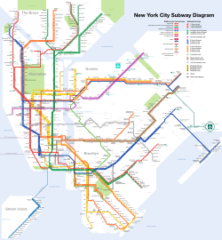
Čeština: Plán sítě newyorského metra Deutsch: Netzplan der New Yorker U-Bahn English: Map of the New York City Subway Español: Plano del Metro de Nueva York Français : Carte du métro de New York Română: Hartă a metroului din New York 中文: 纽约地铁路线图 |
| SVG ανάπτυξη | |
| Ημερομηνία | |
| Πηγή | I created this work entirely by myself. Subway service information taken from the MTA. |
| Δημιουργός |
I, User:CountZ, Jake Berman. A link to my website, [1] would also be appreciated if you reuse this file. |
| Georeferencing | If inappropriate please set warp_status = skip to hide. |
| άλλες εκδόσεις | File:NYC_subway-4C.svg, File:NYC_subway-4b-shrunk-2.svg |

Αδειοδότηση
CountZ at Αγγλικά Βικιπαίδεια, ο κάτοχος των πνευματικών δικαιωμάτων αυτού του έργου, το δημοσιεύει δια του παρόντος υπό την εξής άδεια χρήσης:
Το αρχείο διανέμεται υπό την άδεια Creative Commons Αναφορά προέλευσης-Παρόμοια διανομή 3.0 Μη εισαγόμενη
Απόδοση:
- Είστε ελεύθερος:
- να μοιραστείτε – να αντιγράψετε, διανέμετε και να μεταδώσετε το έργο
- να διασκευάσετε – να τροποποιήσετε το έργο
- Υπό τις ακόλουθες προϋποθέσεις:
- αναφορά προέλευσης – Θα πρέπει να κάνετε κατάλληλη αναφορά, να παρέχετε σύνδεσμο για την άδεια και να επισημάνετε εάν έγιναν αλλαγές. Μπορείτε να το κάνετε με οποιοδήποτε αιτιολογήσιμο λόγο, χωρίς όμως να εννοείται με οποιονδήποτε τρόπο ότι εγκρίνουν εσάς ή τη χρήση του έργου από εσάς.
- παρόμοια διανομή – Εάν αλλάξετε, τροποποιήσετε ή δημιουργήσετε πάνω στο έργο αυτό, μπορείτε να διανείμετε αυτό που θα προκύψει μόνο υπό τους όρους της ίδιας ή συμβατής άδειας με το πρωτότυπο.
Assessment
|
This image was selected as picture of the day on Wikimedia Commons for 8 October 2011. It was captioned as follows: English: Map of the New York City Subway Other languages:
Čeština: Plán sítě newyorského metra s anglickými popisky, stav říjen 2011 Dansk: Kort over New York City Subway. English: Map of the New York City Subway Español: Mapa del Metro de la Ciudad de Nueva York (EE.UU.) Français : Carte du métro de New York Italiano: Mappa della metropolitana di New York. Magyar: New York-i metró térképe. Nederlands: Kaart van de metro van New York Română: Hartă a metroului din New York. Русский: Схема Нью-йоркского метрополитена Українська: Карта Нью-Йоркського метрополітену. 한국어: 뉴욕 지하철 노선도. 日本語: ニューヨーク市の地下鉄路線図 中文: 纽约地铁线路图。 |
Καταγραφές ανεβασμάτων πρωτότυπου αρχείου
Transferred from en.wikipedia to Commons by Train2104 using CommonsHelper.
Η αρχική σελίδα περιγραφής ήταν εδώ. Όλα τα ακόλουθα ονόματα χρήστη αναφέρονται στην en.wikipedia.
- 2011-02-16 23:04 CountZ 2500×2700 (3397859 bytes) minor modifications
- 2011-02-04 21:28 CountZ 2500×2700 (3381913 bytes) added neighborhoods and borough lines
- 2011-01-20 16:12 CountZ 2500×2700 (3072936 bytes) Modified Staten Island service to show ferry connections; clarified Times Sq wheelchair access
- 2011-01-15 22:33 Train2104 2500×2700 (5298094 bytes) Corrected naming of certain stations, line color to match {{NYCS color}}, Ballpark closed
- 2011-01-11 17:29 CountZ 2500×2700 (3075835 bytes) rearranged herald square, fixed PATH stations
- 2011-01-11 00:18 CountZ 2500×2700 (3053095 bytes) Past upload did not upload correctly.
- 2011-01-11 00:13 CountZ 2500×2700 (3052896 bytes) Corrected error on the Broadway Line
- 2011-01-10 21:23 CountZ 2500×2700 (3232134 bytes) comprehensive rework of the map
- 2010-12-31 17:11 CountZ 2500×2700 (3234151 bytes) Updated Nostrand Avenue service pattern
- 2010-12-11 17:11 CountZ 2500×2700 (3230578 bytes) Added Jay Street-Lawrence Street transfer Renamed Fulton-Broadway-Nassau to its new name (Fulton Street)
- 2010-09-23 15:03 CountZ 2500×2700 (3237347 bytes) minor updates, including B/Q on the Brighton Line
- 2010-05-31 15:26 CountZ 2500×2700 (3213246 bytes) minor edits for new service changes
- 2010-04-16 17:44 CountZ 2500×2700 (3199398 bytes) Updated to reflect MTA service changes
- 2010-03-02 21:34 CountZ 2500×2700 (3222199 bytes) minor update to test Illustrator
- 2010-01-18 22:20 CountZ 2500×2700 (3237236 bytes) Update: Added Staten Island express service.
- 2009-12-20 19:08 Dream out loud 2500×2700 (4410399 bytes) fixed blue (water) background
- 2009-12-19 03:10 Dream out loud 2500×2700 (4385399 bytes) updated 4 Oct 2009 edit - cleaned up AirTrain JFK, added endashes, updated Aqueduct Racetrack and Cortlandt St BMT
- 2009-11-25 06:58 Dream out loud 2500×2700 (4010699 bytes) converted text to path
- 2009-11-25 06:52 Dream out loud 2500×2700 (3950043 bytes) added endashes to subway services, fixed AirTrain JFK stations
- 2009-11-17 17:05 Dream out loud 2500×2700 (3481944 bytes) added northbound service only for Aqueduct Racetrack
- 2009-10-04 13:53 CountZ 2500×2700 (3218417 bytes) Minor edit: slightly untangled the Eastern Pkwy line.
- 2009-09-30 13:49 CountZ 2500×2700 (3216925 bytes) Minor edit: AirTrain JFK station names fixed.
- 2009-09-30 02:17 CountZ 2500×2700 (3200805 bytes) Okay, it should work this time. Was uploading the wrong file version.
- 2009-09-30 02:12 CountZ 2500×2700 (3196471 bytes) Funny, it didn't remove. Let's try again.
- 2009-09-30 02:06 CountZ 2500×2700 (3196471 bytes) Watermark removed
- 2009-09-27 15:25 CountZ 2500×2700 (3195870 bytes) Fixed a couple of street names: 9 -> 9 St; 125 -> 125 St; 8 St -> 8 St/ NYU
- 2009-09-27 15:16 CountZ 2500×2700 (3196585 bytes)
- 2009-09-27 14:48 CountZ 2500×2700 (3195913 bytes) Corrected j-z skip-stop service in Brooklyn.
- 2009-09-26 20:23 CountZ 2500×2700 (3197825 bytes) {{Information |Description = Map of the New York Subway |Source = I (~~~) created this work entirely by myself. Also: [http://www.mta.info/nyct/maps/submap.htm] |Date = ~~~~~ |Author = ~~~ |other_versions = [[:File:NYC_su
Ιστορικό αρχείου
Πατήστε σε μια ημερομηνία/ώρα για να δείτε το αρχείο όπως εμφανιζόταν εκείνη την χρονική στιγμή.
| Ημερομηνία/Ώρα | Μικρογραφία | Διαστάσεις | Χρήστης | Σχόλιο | |
|---|---|---|---|---|---|
| τρέχον | 05:39, 8 Δεκεμβρίου 2022 | | 512 × 553 (2,63 MB) | wikimediacommons>TFSyndicate | Added more 'accessible station' symbols |
Χρήση αρχείου
Η ακόλουθη σελίδα χρησιμοποιεί προς αυτό το αρχείο: