Αρχείο:PIA21465 - North Polar Layers.jpg

Σύνοψη
| Περιγραφή |
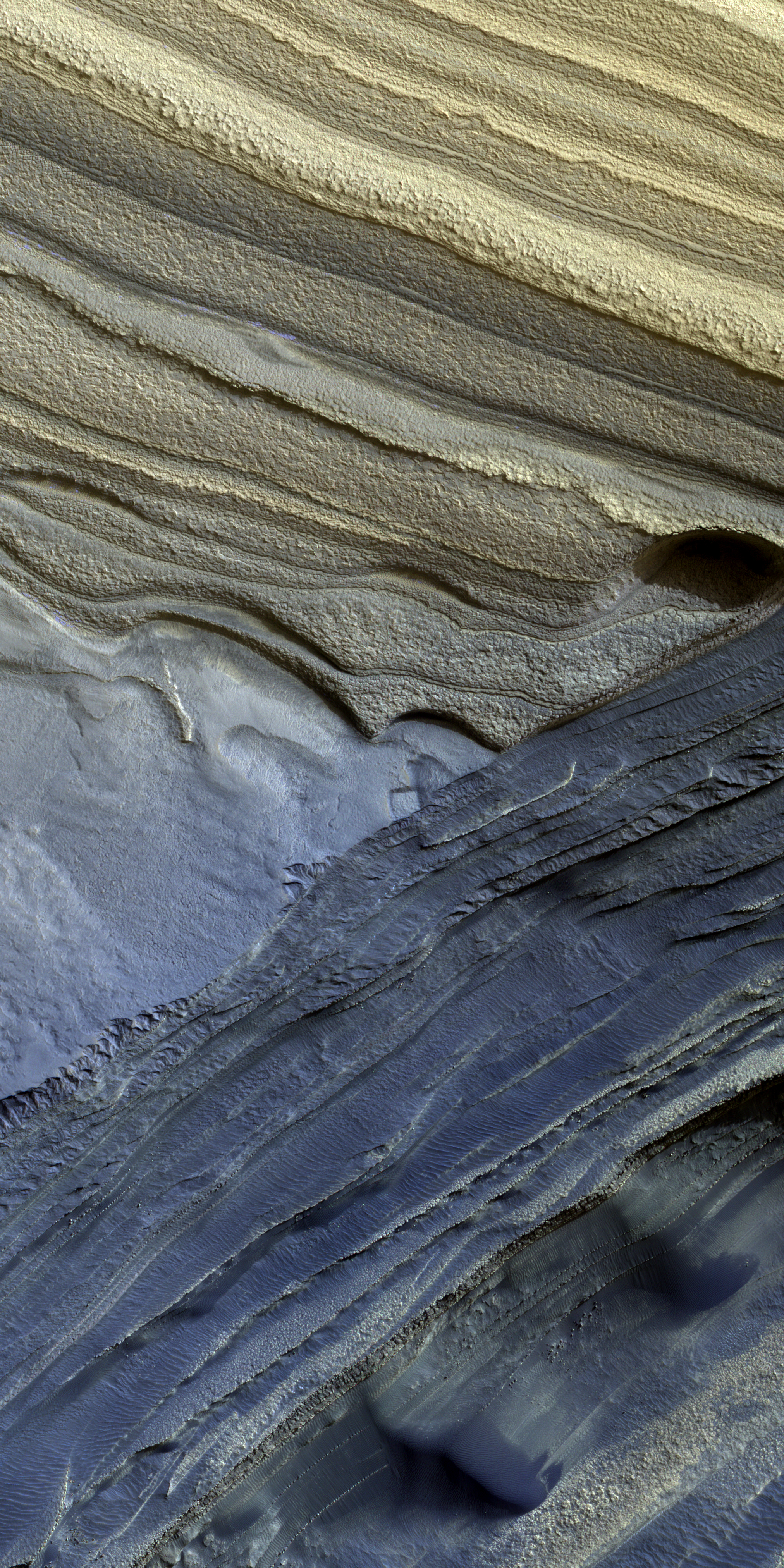
English: The North Polar layered deposits are a 3-kilometer thick stack of dusty water ice layers that are about 1000 kilometers across. The layers record information about climate stretching back a few million years into Martian history.
In many locations erosion has created scarps and troughs that expose this layering. The tan colored layers are the dusty water ice of the polar layered deposits; however a section of bluish layers is visible below them. These bluish layers contain sand-sized rock fragments that likely formed a large polar dunefield before the overlying dusty ice was deposited. The lack of a polar ice cap in this past epoch attests to the variability of the Martian climate, which undergoes larger changes over time than that of the Earth. The map is projected here at a scale of 50 centimeters (19.6 inches) per pixel. [The original image scale is 63.6 centimeters (25 inches) per pixel (with 2 x 2 binning); objects on the order of 191 centimeters (75.2 inches) across are resolved.] North is up. The University of Arizona, Tucson, operates HiRISE, which was built by Ball Aerospace & Technologies Corp., Boulder, Colo. NASA's Jet Propulsion Laboratory, a division of Caltech in Pasadena, California, manages the Mars Reconnaissance Orbiter Project for NASA's Science Mission Directorate, Washington. |
| Ημερομηνία | 18 July 2010 (published 28 February 2017) |
| Πηγή | Catalog page · Full-res (JPEG · TIFF) |
| Δημιουργός | NASA/JPL-Caltech/Univ. of Arizona |
| Location on Mars | View this and other nearby images on: Google Maps |
|---|
This image or video was catalogued by Jet Propulsion Laboratory of the United States National Aeronautics and Space Administration (NASA) under Photo ID: PIA21465. This tag does not indicate the copyright status of the attached work. A normal copyright tag is still required. See Commons:Licensing. Other languages:
|
 |
This media is a product of the Mars Reconnaissance Orbiter mission Credit and attribution belongs to the High Resolution Imaging Science Experiment (HiRISE) team, NASA/JPL-Caltech/Univ. of Arizona |
Assessment
|

![[1]](https://hirise-pds.lpl.arizona.edu/PDS/EXTRAS/RDR/ESP/ORB_018600_018699/ESP_018636_2745/ESP_018636_2745_MIRB.abrowse.jpg)
![[2]](https://hirise-pds.lpl.arizona.edu/PDS/EXTRAS/RDR/ESP/ORB_018600_018699/ESP_018636_2745/ESP_018636_2745_COLOR.abrowse.jpg)
Αδειοδότηση
| Αυτό το αρχείο είναι κοινό κτήμα γιατί δημιουργήθηκε από την NASA. Η πολιτική πνευματικής ιδιοκτησίας της NASA δηλώνει ότι «Το υλικό της NASA δεν προστατεύεται από copyright εκτός αν αναφέρεται». (Σελίδα με την πολιτική πνευματικής ιδιοκτησίας της NASA ή Πολιτική Χρήσης Εικόνων του JPL). | ||
 |
Προσοχή:
|
Ιστορικό αρχείου
Πατήστε σε μια ημερομηνία/ώρα για να δείτε το αρχείο όπως εμφανιζόταν εκείνη την χρονική στιγμή.
| Ημερομηνία/Ώρα | Μικρογραφία | Διαστάσεις | Χρήστης | Σχόλιο | |
|---|---|---|---|---|---|
| τρέχον | 09:52, 2 Απριλίου 2017 | | 2.880 × 1.800 (6,2 MB) | wikimediacommons>Gnash | Optimized file size. |
Χρήση αρχείου
Η ακόλουθη σελίδα χρησιμοποιεί προς αυτό το αρχείο: