Αρχείο:TSP Deutschland 3.png
Μετάβαση στην πλοήγηση
Πήδηση στην αναζήτηση
Δεν διατίθεται υψηλότερη ανάλυση.
TSP_Deutschland_3.png (326 × 350 εικονοστοιχεία, μέγεθος αρχείου: 15 KB, τύπος MIME: image/png)
Σύνοψη

|
This map of europe image could be re-created using vector graphics as an SVG file. This has several advantages; see Commons:Media for cleanup for more information. If an SVG form of this image is available, please upload it and afterwards replace this template with
{{vector version available|new image name}}.It is recommended to name the SVG file “TSP Deutschland 3.svg”—then the template Vector version available (or Vva) does not need the new image name parameter. |
| Περιγραφή |
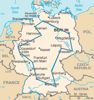
Kürzester Rundreiseweg durch die 15 größten Städte Deutschlands (14 sind genannt, es fehlt Dortmund, das knapp östlich von Essen liegt). Insgesamt sind 14!/2 = 43.589.145.600 verschiedene Wege möglich. |
| Ημερομηνία | 21 Οκτωβρίου 2005 (original upload date) |
| Πηγή | https://www.cia.gov/cia/publications/factbook/maps/gm-map.gif |
| Δημιουργός | The original uploader was Kapitän Nemo at Γερμανικά Βικιπαίδεια. |
| Άδεια (Επαναχρησιμοποίηση αυτού του αρχείου) |
https://www.cia.gov/cia/publications/factbook/docs/contributor_copyright.html |
Αδειοδότηση
This image is in the public domain because it contains materials that originally came from the United States Central Intelligence Agency's World Factbook.
|
 |
Καταγραφές ανεβασμάτων πρωτότυπου αρχείου
Transferred from de.wikipedia to Commons using CommonsHelper.
Η αρχική σελίδα περιγραφής ήταν Deutschland 3.PNG εδώ. Όλα τα ακόλουθα ονόματα χρήστη αναφέρονται στην de.wikipedia.
- 2007-01-10 12:45 MrMonstar 328×352× (15511 bytes) {{Information |Beschreibung=Kürzester Rundreiseweg durch die 15 größten Städte Deutschlands. Insgesamt sind [[Fakultät (Mathematik)|14!]]/2 = 43 589 145 600 verschiedene Wege möglich. |Quelle=Auf Basis der modifizierten [https://www.cia.gov/cia/publ
- 2005-10-21 10:44 Kapitän Nemo 328×352× (21053 bytes) == Beschreibung, Quelle und Lizenz == Optimaler Reiseweg eines Handlungsreisenden durch die 15 größten Städte Deutschlands. Auf Basis der modifizierten [http://www.cia.gov/cia/publications/factbook/maps/gm-map.gif CIA-Karte] selbst gezeichnet. == Liz
Ιστορικό αρχείου
Πατήστε σε μια ημερομηνία/ώρα για να δείτε το αρχείο όπως εμφανιζόταν εκείνη την χρονική στιγμή.
| Ημερομηνία/Ώρα | Μικρογραφία | Διαστάσεις | Χρήστης | Σχόλιο | |
|---|---|---|---|---|---|
| τρέχον | 15:36, 1 Ιανουαρίου 2021 | | 326 × 350 (15 KB) | wikimediacommons>Ras67 | frame removed |
Χρήση αρχείου
Η ακόλουθη σελίδα χρησιμοποιεί προς αυτό το αρχείο: